May 13, 2026
Captain's Log, May 13, 2026
A stalled frontal boundary over central Florida, a well-defined high pressure system over the north Atlantic, and a mean layer ridge north of the Antilles are combining to surge winds along the southern Florida coastline today. West breezes are freshening from light to moderate through the afternoon, with small craft advisories posted for the upper Keys from Ocean Reef to Craig Key. Showers are pulsing on and off across all coastal waters, but the good news: the pressure gradient is expected to collapse late in the week, bringing a return to variable light winds by Friday.
NOAA marine forecast summary
Source: National Weather Service Key West coastal waters forecast, issued 4:21 AM EDT Wednesday, May 13, 2026
- Synopsis: A stalled frontal boundary over central Florida, a high pressure system over the north Atlantic, and a ridge north of the Antilles are driving a wind surge along the southern Florida coast. Westerly winds are set to freshen from light to gentle to moderate-to-fresh along northeastern coastal zones today. Showers will continue pulsing across all Keys coastal waters. The pressure gradient collapses late in the week, bringing periods of variable winds with high confidence.
- Wind (Hawk Channel, Islamorada/Craig Key area): Southwest to west 5-10 knots, increasing to 15-20 knots this afternoon, Small Craft Should Exercise Caution
- Hawk Channel seas: Around 1 foot, flat inside despite building wind
- Offshore Straits: 1-2 feet, wave detail: south to southwest 1 foot at 3 seconds
- Weather: A slight chance of showers and thunderstorms today, chance tonight
Gulf Stream position (as of May 12)
NOAA’s latest shoreward edge report:
- 6 NM southeast of Alligator Reef Light, closest it’s been to Islamorada in weeks
- 4 NM southeast of Molasses Reef Light, incredibly close to Key Largo
- 3 NM southeast of Carysfort Reef Light, pinned right on the upper Keys reef edge
- 7 NM south of Looe Key
- 6 NM southeast of Sombrero Key Light
- 6 NM south of Sand Key Light
- 9 NM south of Cosgrove Shoal Light
- 35 NM south of Dry Tortugas Light
The Gulf Stream has pushed significantly closer to the reef line since last week’s report. At 6 miles southeast of Alligator, the bluewater edge is within spitting distance of Islamorada. At 4 miles off Molasses, that’s a 10-minute run from the reef.
Reef conditions, Islamorada line
Molasses Reef
- Small craft caution zone, west winds building to 15-20 knots this afternoon
- Seas around 1 foot, flat but wind is the factor
- Gulf Stream edge at 4 miles southeast, practically on top of the reef
- The wind surge today means: fish the morning before the breeze cranks up
- A slight chance of showers and thunderstorms
Conch Reef
- Wind surge builds through the afternoon, morning window is the play
- Light southwest breeze early gives way to gusty west 15-20 after lunch
- The afternoon wind will build short-period chop inside Hawk Channel
- Same Gulf Stream proximity advantage, clean water is close
Davis Reef
- Mid-reef, same wind profile, morning calm, afternoon gusty
- Mutton drifts in 60-80 feet on the morning incoming
- By afternoon the breeze makes anchoring the better call
- Showers pulsing on and off, expect isolated cells moving through
Crocker Reef
- West wind 15-20 afternoon makes the lee side of the reef the play
- Morning window with smooth water is the money time
- Cobia patrolling reef edges, keep eyes open
- Light chop through the morning, moderate chop by afternoon
Alligator Reef
- Gulf Stream edge at 6 miles southeast, closest Islamorada access
- Afternoon west wind surge makes the offshore run a little sporty but doable
- Short-period 1-foot chop at 3 seconds is manageable
- The proximity of bluewater means the color change is a quick ride
Tennessee Reef
- Same wind surge pattern, same morning advantage
- Less boat traffic midweek, clean structure in 50-70 feet
- The afternoon west breeze creates a lee seam on the east side of the reef
- Isolated showers moving through
Tides & water
Tides, Islamorada (Upper Matecumbe Key, Florida Bay)
- Low: 2:32 AM at 0.2 ft
- High: 8:19 AM at 1.6 ft, morning bite window on the incoming
- Low: 3:08 PM at 0.3 ft, midday slack
- High: 8:55 PM at 1.5 ft, evening incoming
The 8:19 AM high tide is the golden window. Morning incoming on smooth water before the wind builds. The afternoon high at 8:55 PM sets up a productive evening bite for anyone staying late.
Water temperature
- Nearshore Islamorada: Approx 79-81°F
- Reef temperature: Running 81-83°F
- Gulf Stream: Carrying 83-85°F bluewater, within 4-6 miles of the reef
- Bait activity is high, with the Gulf Stream this close, baitfish are concentrated along the reef edge
Moon phase
- Waning Crescent, new moon coming May 16 (Saturday)
- Tide range today is moderate (0.2 ft to 1.6 ft)
- Building toward new moon means increasing water movement through the weekend
- Best bite days: Thursday through Sunday as the tidal swing peaks
Species outlook
Yellowtail snapper
- Outlook: Good
- Fish the morning incoming tide (before 8:19 AM high) for best results
- Chum slick in 40-60 feet on the reef
- The afternoon breeze will make anchoring a must, too much drift for slick fishing
- Morning bite sharp, afternoon tapers with the building wind
Mutton snapper
- Outlook: Good
- Davis and Crocker in 60-80 feet on the morning incoming
- Live bait on structure during the tide change
- The wind surge will push them tighter to structure by afternoon
- Morning window is the time to put muttons in the box
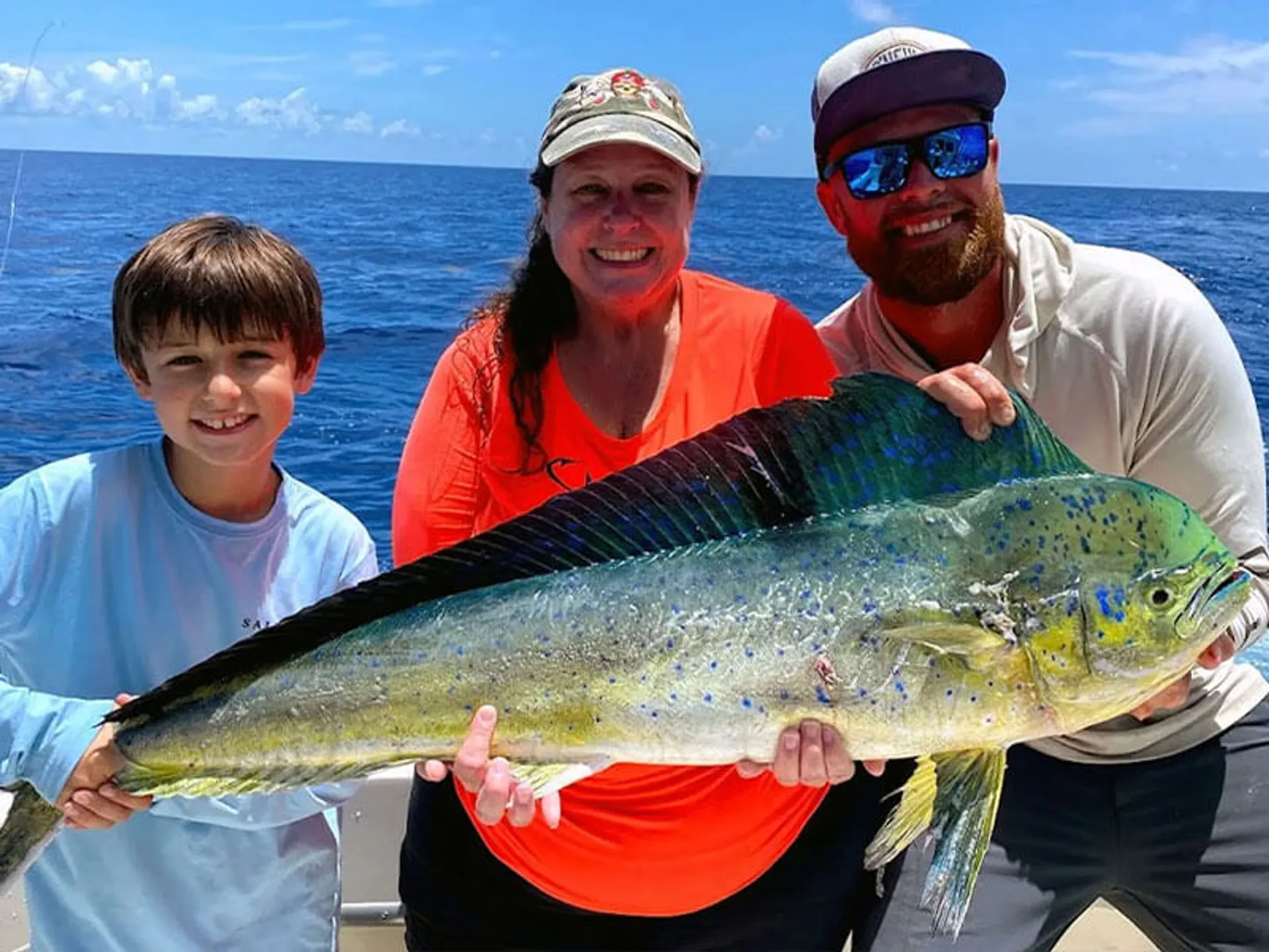
Mahi-Mahi
- Outlook: Good
- Gulf Stream edge at 6 miles off Alligator, 4 miles off Molasses, shortest run in weeks
- That clean bluewater is close enough to make an afternoon look worthwhile
- The wind surge may have stirred up some debris and weed lines
- The morning drop is ideal, smooth water, quick run to bluewater
- Offshore seas at 1-2 feet, still comfortable running
- With the stream pinned this close, mahi have been pushing closer to the reef edge
Kingfish and cero
- Outlook: Good
- The reef edge is active with bait concentrations
- Kings working the drop-offs consistently
- Cero thick on the reef, flashy spoons and ribbonfish getting eaten
- The afternoon breeze doesn’t kill the troll bite on the reef edge
Sailfish
- Outlook: Fair to Good
- With the Gulf Stream at 4-6 miles, sails are working closer to the reef than usual
- Morning bait-and-wait at the color change
- The wind surge tonight/afternoon may stack bait along the current edge
- Not peak season, but the proximity of clean water changes the equation
Tuna (Blackfin)
- Outlook: Fair to Good
- Morning offshore run to the humps or color change
- 1-2 foot offshore seas make the run painless in the morning
- Bait activity is on the uptick with the stream so close
- The humps off Islamorada and Key Largo are the play
Tarpon and backcountry
- Outlook: Good
- Florida Bay today: southwest to west winds 5-10 knots, building to near 15 knots
- Bay waters smooth to light chop, moderate chop by afternoon
- The morning low-to-incoming transition (2:32 AM low → 8:19 AM high) pushes water onto the flats
- Tarpon moving into channels and cuts on the flood
- Protected water is a solid alternative if you want to escape the ocean breeze
- Smaller boats excel in the bay today
Grouper
- Outlook: Good
- Morning deep dropping in 80-120 feet
- Light wind early, building through the day, get the deep drop done before 11 AM
- Reef edge structure holding gags and reds
- Catch-and-release the big spawners
Captain’s recommendation
- Morning is the money window. The wind surge doesn’t build until afternoon. Get a dawn start, fish the incoming tide (8:19 AM high), and be set by 10 AM.
- The Gulf Stream is as close as it gets. Six miles off Alligator, four miles off Molasses. That bluewater edge is a quick run from any upper or mid-Keys launch. Don’t waste this proximity.
- Offshore seas stay comfortable at 1-2 feet through the morning. The issue isn’t sea state, it’s the afternoon wind freshening to 15-20 knots.
- Watch the radar. Showers are pulsing on and off across all coastal waters. They’re not washouts, but they’re moving through regularly today.
- If you’re a small boat, Florida Bay and backcountry are the call. Protected water stays fishable even when Hawk Channel gets sporty this afternoon.
- The weekend looks excellent. The pressure gradient collapses Friday, winds go variable and light, and new moon Saturday means building tides. Book Thursday through Sunday.
- Small craft caution zone extends from Ocean Reef to Craig Key (upper Keys). If you’re launching from Tavernier or Key Largo, factor in the afternoon west wind surge.
Short-Range outlook
Tonight
- West winds 15-20 knots, decreasing to near 15 knots
- Hawk Channel seas 1-2 feet
- Offshore Straits 1-2 feet, wave detail: west 2 feet at 3 seconds, north-northeast 1 foot at 9 seconds (long-period swell arriving)
- A chance of showers with a slight chance of thunderstorms
Thursday, May 14
- West to northwest winds 10-15 knots, easing from today
- All zones: seas 1-2 feet
- Offshore wave detail: west 2 feet at 4 seconds, north-northeast 1 foot at 8 seconds
- A slight chance of showers and thunderstorms
- The gradient starts to relax, improving conditions
Thursday night
- Northwest to north winds 10-15 knots, decreasing to 5-10 knots
- Seas 1-2 feet
- A slight chance of showers and thunderstorms
Friday, May 15
- Variable winds near 5 knots, the pressure gradient collapses
- All zones: seas 1 foot or less
- Back to flat, calm, fishable conditions
- A slight chance of showers and thunderstorms
Saturday, May 16, New Moon
- Variable winds near 5 knots, becoming east to southeast
- Seas 1 foot or less nearshore, 1-2 feet offshore
- A slight chance of showers and thunderstorms
- New moon + calm winds = best fishing day of the pattern
Sunday, May 17
- East winds 10-15 knots, gradient re-establishes
- Seas around 2 feet nearshore, 2-3 feet offshore
- A slight chance of showers
Final take
Today is a tale of two halves. The morning delivers smooth water, a building incoming tide, and the closest Gulf Stream positioning we’ve seen in weeks, bluewater at just 4-6 miles off the reef. The afternoon brings a wind surge to 15-20 knots across the upper Keys with a small craft caution posted for the Ocean Reef to Craig Key zone.
The smart play: launch early, fish the incoming tide hard through 10 AM, make the quick run to the Gulf Stream edge for a bluewater pass, and have lines up before the breeze gets serious. If you’re fishing the mid or lower Keys, the wind is lighter (west 10-15 instead of 15-20), giving you more afternoon flexibility.
The good news for the week: this wind surge is temporary. The pressure gradient collapses by Friday, ushering in variable light winds through the weekend, coinciding with the new moon on Saturday. Thursday through Sunday is shaping up to be the strongest fishing block of the pattern.
Get out this morning and thank yourself later.
Reports based on NOAA Marine Forecast FZUS52 KKEY issued 4:21 AM EDT Wednesday, May 13, 2026. Midday update based on NOAA forecast issued 10:17 AM EDT Wednesday, May 13, 2026. Tide predictions for Islamorada (Upper Matecumbe Key, Florida Bay). Moon phase: Waning Crescent (new moon May 16). Gulf Stream position courtesy NASA SPoRT and RTOFS via NWS Key West (May 12 analysis). Small Craft Should Exercise Caution in effect from Ocean Reef to Craig Key for increasing winds.
Midday addendum, 10:17 AM update
NOAA issued a refreshed forecast at 10:17 AM EDT. Here’s what changed since the 4:21 AM morning report:
Wind forecast adjusted down, Mid Keys
The morning report called for 15-20 knots across Hawk Channel this afternoon. The midday update dials it back for the mid Keys:
| Zone | Morning Call | Midday Update |
|---|---|---|
| Ocean Reef to Craig Key (upper Keys) | SW to W 15-20 | SW to W 15-20 confirmed, Small Craft Caution holds |
| Craig Key to Seven Mile (mid Keys) | SW to W 15-20 | SW to W 10-15, a notch lighter |
| Florida Bay | N/A (not detailed) | W to SW near 15, moderate chop building |
| Bayside/Gulfside (Craig Key west) | N/A (not detailed) | SW to W 10-15, seas 1-2 ft |
Bottom line: If you’re fishing out of Islamorada south through Marathon, the afternoon wind tops out around 10-15, not 15-20. The upper Keys (Tavernier, Key Largo) still get the full 15-20 punch. Small craft caution is zone-specific, Ocean Reef to Craig Key only.
What’s actually happening
The new synopsis adds a critical detail the morning forecast omitted: daytime heating over South Florida is one of the three factors driving the wind surge. The developing low in the eastern Gulf, the Atlantic high, and afternoon thermal heating are all combining to push westerlies this afternoon. That’s why the upper Keys see a bigger response, they’re closer to the mainland heating gradient.
Seas: slightly higher offshore tonight
The morning report didn’t include offshore wave detail. The midday update adds:
- Offshore upper Straits this afternoon: Waves southwest 1 ft at 3 seconds, short-period chop, building
- Tonight: West 2 ft at 3 seconds plus a north-northeast 1 ft at 9 seconds, that’s a longer-period swell arriving from the north overnight
- Offshore seas tonight: 2-3 feet, subsiding to around 2 feet
The 9-second north-northeast swell is new, it wasn’t factored into the morning’s short-range outlook. This will be noticeable overnight on the reef edge and outside Hawk Channel.
Florida Bay clarified
The morning report didn’t have a dedicated midday slot for Florida Bay. The 10:17 AM update gives it:
This Afternoon: Variable winds near 5 knots, becoming W/SW and increasing to near 15 knots. Bay waters smooth → moderate chop. A slight chance of showers and thunderstorms.
Tonight: West winds near 15 knots, decreasing to 10-15. Moderate chop. A chance of showers with slight chance of thunderstorms.
No changes to
- Gulf Stream position (still 6 miles off Alligator, 4 off Molasses, from May 12 analysis)
- Tides and moon phase
- Thursday through Sunday outlook, the pressure gradient still collapses by Friday
- Shower/thunderstorm chances, slight chance this afternoon, chance tonight
What this means for your afternoon
The morning recommendation to fish early still stands, but the wind won’t crank quite as hard as initially feared if you’re south of Craig Key. For Islamorada launches:
- Upper Keys (Tavernier north): Plan for 15-20 west wind this afternoon, choppy Hawk Channel. Small craft caution in effect.
- Islamorada south through Marathon: 10-15 west wind with seas 1-2 feet. Manageable. The window extends past lunch.
- Florida Bay: Building to near 15 west, moderate chop. Protected water holds up.
- Offshore: 1-2 ft seas building to 2-3 ft tonight. The 9-second north-northeast swell arrives overnight, keep that in mind if doing an extended run.
The 9-second north-northeast swell arriving tonight is the sleeper here. It’ll show up on the reef edge and outside Hawk Channel after dark. Not a daytime factor, but if you’re running offshore at dawn tomorrow, expect some leftover groundswell mixing with the local wind chop.
Captain’s midday pivot
- Mid Keys got a break, the wind tops out at 10-15 instead of 15-20. More fishable afternoon than the morning forecast suggested.
- Upper Keys, same story, still gusting 15-20. Morning tight window holds.
- Radar check: Showers are pulsing, those isolated cells the forecast mentioned are real. Keep an eye west.
- Tomorrow outlook unchanged, easing Thursday, flat by Friday. Weekend still looks excellent.
The updated forecast is good news for anyone launching south of Tavernier. The wind surge is real but zone-specific. Plan accordingly.
Evening addendum, 4:18 PM NOAA update for tonight & Thursday
NOAA’s 4:18 PM EDT evening forecast is in. Here’s what’s happening now and what tomorrow looks like:
Evening recap
The wind surge materialized as predicted. Hawk Channel from Ocean Reef to Craig Key saw southwest to west winds 15-20 knots through the late afternoon, with small craft caution conditions. Mid Keys (Craig Key west) peaked around 10-15 knots west, the midday downgrade held true. Florida Bay built to a moderate chop under west winds near 15 knots. Isolated showers pushed through on schedule.
Seas held: Hawk Channel around 2 feet, 1-2 feet mid Keys, 1-2 feet offshore, comfortable despite the breeze. The 9-second north-northeast swell has started arriving on the reef edge and outside Hawk Channel, mixing with the local west wind chop. That’ll be the overnight factor.
The Gulf Stream proximity advantage remains, still pinned at 6 miles off Alligator, 4 miles off Molasses. Anyone who made the morning bluewater run got rewarded with a short steam to clean water.
Tonight’s conditions
| Zone | Wind | Water | Weather |
|---|---|---|---|
| Hawk Channel (upper Keys) | SW to W 15-20 → W near 15 | Seas around 2 ft, choppy | Chance showers, slight chance thunderstorms |
| Hawk Channel (mid Keys) | SW to W near 15 → W 10-15 | Seas 1-2 ft, moderate chop | Chance showers, slight chance thunderstorms |
| Florida Bay | W near 15 | Moderate chop | Chance showers, slight chance thunderstorms |
| Bayside/Gulfside | W near 15 | Seas 1-2 ft, moderate chop | Chance showers, slight chance thunderstorms |
| Offshore Straits | W, becoming NW 10-15 | Seas 2-3 ft (west 2ft@3sec + NNE 1ft@9sec) | Chance showers, slight chance thunderstorms |
The north-northeast 1-foot at 9 seconds is the feature to watch overnight. It’s a longer-period swell arriving from the north, mixing with the local west wind sea. This combination creates lumpy conditions on the reef edge and outside Hawk Channel through the early morning hours Thursday.
Thursday, May 14, outlook
| Timeframe | Wind | Seas | Confidence |
|---|---|---|---|
| Morning | W 10-15 knots | 1-2 ft | Good |
| Afternoon | W 10-15 knots, decreasing | 1-2 ft | Good |
| Night | NW to N 10-15 → 5-10 knots | 1-2 ft → 1 ft or less | Good |
Hawk Channel upper Keys: West winds near 15 knots, decreasing to 10-15. Seas around 2 feet, subsiding. A slight chance of showers and thunderstorms.
Hawk Channel mid Keys: West to northwest 10-15 knots. Seas 1-2 feet. Light to moderate chop.
Florida Bay: West winds 10-15 knots, decreasing to 5-10. Light to moderate chop, becoming smooth to light chop. A slight chance of showers and thunderstorms.
Offshore: West 2 feet at 4 seconds, north-northeast 1 foot at 8 seconds (lingering overnight swell, easing). Seas subsiding to around 1-2 feet.
Key point: Thursday is an easing day. The gradient relaxes. Winds drop 5 knots across the board compared to today. The overnight NNE swell will still be felt early morning but fades through the day.
Friday, May 15, the collapse
The pressure gradient collapses. Variable winds near 5 knots. All zones: seas 1 foot or less. Nearshore waters go smooth. Offshore settles to flat. This is the cleanest day of the pattern, the transition day before the east wind regime starts rebuilding.
Saturday, May 16, New Moon
Light variable winds turning east to southeast 5-10 knots. Seas around 1 foot. A slight chance of showers and thunderstorms. New moon + calm conditions = peak fishing day. The tidal swing is building, expect more water movement, better feeding windows, and the first significant east breeze influence.
Sunday & beyond
Sunday through Monday night: east winds 10-15 knots, building to 15-20 by Monday night. Seas climb from 1-2 to 3-4 feet (occasionally 5 feet Monday night nearshore). The easterly trade wind regime re-establishes early next week. Chop builds. Fish it while it’s flat.
What changed this evening
- Synopsis refined: The evening update clarifies the mechanism. A developing area of low pressure along a frontal boundary over central Florida is interacting with the North Atlantic high. That’s more specific than the morning’s read.
Targeted in this report
Conditions data provided by FishIntel.ai, fishing intelligence for the Florida Keys and beyond.